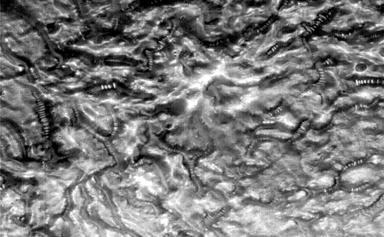
| コイル状のオブジェクト群 |
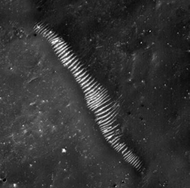
| A M23-01405の画像 |
無数に絡まるコイル。まるで何かの配線のようにも見える。これは、それとも配管システムなのだろうか?
二股に分かれたり、T字型に連結しているものもある。とても自然の産物には思えない。
はたまた有機的な生物の残骸なのだろうか?
Acquisition parameters Image ID (picno): M23-01405 Image start time: 2001-01-21T12:25:34.28 SCET Image width: 640 pixels Image height: 4224 pixels Line integration time: 0.6026 millisec Pixel aspect ratio: 1.20 Crosstrack summing: 3 Downtrack summing: 3 Compression type: MOC-DCT-3 Gain mode: 8A (hexadecimal) Offset mode: 20 (decimal) |
Derived values Longitude of image center: 263.14°W Latitude of image center: 30.33°N Scaled pixel width: 4.55 meters Scaled image width: 2.91 km Scaled image height: 23.14 km Solar longitude (Ls): 106.15° Local True Solar Time: 14.23 decimal hours Emission angle: 0.27° Incidence angle: 30.39° Phase angle: 30.37° North azimuth: 93.52° Sun azimuth: 0.01° Spacecraft altitude: 405.08 km Slant distance: 405.08 km |
Policy regarding use of processed images
Release date: 8 October 2001
NASAのオリジナル画像のアドレス http://www.msss.com/moc_gallery/m19_m23/images/M23/M2301405.html |
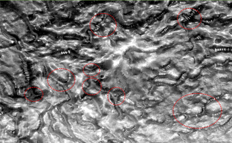
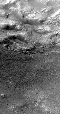
| B M03-06752の画像 |
Hint: configure your browser to recognize files with extensions
.IMG and .IMQ as MIME type
application/octet-stream and to save them to disk.
Acquisition parameters Image ID (picno): M03-06752 Image start time: 1999-08-04T16:05:32.98 SCET Image width: 512 pixels Image height: 3968 pixels Line integration time: 0.4821 millisec Pixel aspect ratio: 1.07 Crosstrack summing: 4 Downtrack summing: 4 Compression type: MOC-PRED-X-5 Gain mode: 6A (hexadecimal) Offset mode: 30 (decimal) |
Derived values Longitude of image center: 75.94°W Latitude of image center: 31.19°S Scaled pixel width: 5.56 meters Scaled image width: 2.84 km Scaled image height: 23.62 km Solar longitude (Ls): 182.15° Local True Solar Time: 14.80 decimal hours Emission angle: 0.25° Incidence angle: 49.96° Phase angle: 49.83° North azimuth: 93.51° Sun azimuth: 32.46° Spacecraft altitude: 370.70 km Slant distance: 370.70 km |
Policy regarding use of processed images
Release date: 22 May 2000
http://barsoom.msss.com/moc_gallery/ab1_m04/images/M0306752.html
NASAのオリジナル画像のアドレス: http://barsoom.msss.com/moc_gallery/ab1_m04/images/M0306752.html |
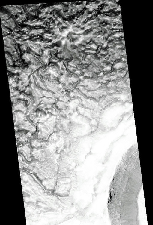
| C M07-00566の画像 |
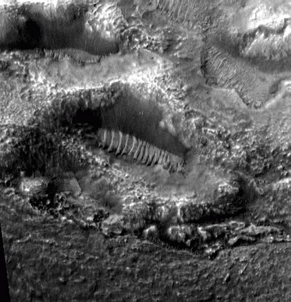
Acquisition parameters Image ID (picno): M07-00566 Image start time: 1999-09-03T13:39:05.69 SCET Image width: 1024 pixels Image height: 4480 pixels Line integration time: 0.7231 millisec Pixel aspect ratio: 1.61 Crosstrack summing: 2 Downtrack summing: 2 Compression type: MOC-PRED-X-5 Gain mode: 6A (hexadecimal) Offset mode: 24 (decimal) |
Derived values Longitude of image center: 109.68°W Latitude of image center: 49.55°S Scaled pixel width: 2.76 meters Scaled image width: 2.84 km Scaled image height: 19.94 km Solar longitude (Ls): 199.53° Local True Solar Time: 14.90 decimal hours Emission angle: 0.26° Incidence angle: 54.99° Phase angle: 54.82° North azimuth: 94.61° Sun azimuth: 38.24° Spacecraft altitude: 370.07 km Slant distance: 370.08 km |
Policy regarding use of processed images
Release date: 16 October 2000
NASAのオリジナル画像のアドレス: http://www.msss.com/moc_gallery/m07_m12/images/M07/M0700566.html |
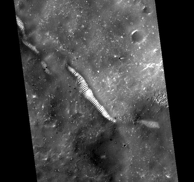
| D M13-00983の画像 |
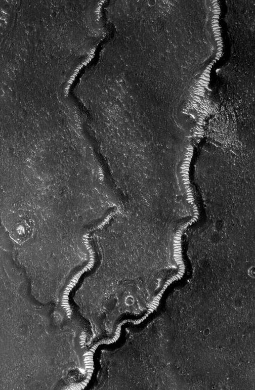
Image Width: 1.94
Miles
Acquisition parameters Image ID (picno): M13-00983 Image start time: 2000-03-15T01:15:20.70 SCET Image width: 512 pixels Image height: 5632 pixels Line integration time: 0.4821 millisec Pixel aspect ratio: 0.95 Crosstrack summing: 4 Downtrack summing: 4 Compression type: MOC-PRED-X-5 Gain mode: 6A (hexadecimal) Offset mode: 38 (decimal) |
Derived values Longitude of image center: 225.79°W Latitude of image center: 35.73°N Scaled pixel width: 6.12 meters Scaled image width: 3.13 km Scaled image height: 32.84 km Solar longitude (Ls): 318.56° Local True Solar Time: 13.04 decimal hours Emission angle: 0.17° Incidence angle: 54.17° Phase angle: 54.23° North azimuth: 93.59° Sun azimuth: 292.25° Spacecraft altitude: 408.63 km Slant distance: 408.63 km |
Policy regarding use of processed images
Release date: 4 April 2001
NASAのオリジナル画像のアドレス: http://www.msss.com/moc_gallery/m13_m18/images/M13/M1300983.html |
| SEO | [PR] 爆速!無料ブログ 無料ホームページ開設 無料ライブ放送 | ||


